Page 26 - Keeyask_ArchaeologyPhotoBook_WebVersion
P. 26

ARCH AEO LO G IC AL SITE:
                HbKu-08 NORTH SHORE

                                              Caribou Island


                                                                                                    A R C H A EO LO G IC A L       SITE T YPE
                                                                                                    SU R VEY M E TH O D S          Lith ic 	w o rksh o p
                                                                                                    •	Pe d e strian 	(W alkin g )	Su rve y
                               H bKu-08                                                                                            A R TIFAC TS FO U N D
                                                                                                    •	Su rfac e 	C o lle c tio n
                                                                                                                                   1 0
                                                                                                    C U LTU R A L A FFILIATIO N S  •	Lith ic 	flake s	A
                                                                                                    P re -E u ro p e a n  C o n ta c t
                                                                                                    (ca . 400-12,000 yea rs a g o )


 Gull Lake        Gull Lake
 Nelson River


                                                                                                                A
 Nelson River

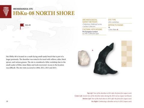
        Site HbKu-08 is located on a south facing small sandy beach that is part of a

        larger peninsula. The shoreline was noted to be treed with willows, alder, black
        spruce, and various grasses. The site is considered a lithic workshop due to the
        small scatter of lithic stone flakes and tools recovered. Access to the location                                                           C M
        was difficult. The site visits occurred in 2004, 2012, 2013 and 2015.


                                                                                                          Top Left: View of the shoreline in 2013 after the forest fire (aspect west).
                                                                                           Center Left: Aerial view of the shoreline taken during the 2012 survey (aspect northeast).
                                                                                                    Bottom Left: View of the back shore in 2013 after the forest fire (aspect east).
        18                                                                                                     Far Right: Conducting a shoreline survey in 2012 (aspect east).
   21   22   23   24   25   26   27   28   29   30   31