Page 42 - Keeyask_ArchaeologyPhotoBook_WebVersion
P. 42

ARCH AEO LO G IC AL SITE:                                             Caribou Island
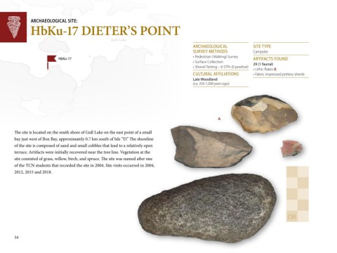
                HbKu-17 DIETER’S POINT


 Gull Lake                                                Gull Lake
 Nelson River                                                                                       A R C H A EO LO G IC A L       SITE T YPE

                                                                                                    SU R VEY M E TH O D S
                                                                                                                                   C am p site
                                                                                                    •	Pe d e strian 	(W alkin g )	Su rve y
                               H bKu-17                                                                                            A R TIFAC TS FO U N D
 Nelson River                                                                                       •	Su rfac e 	C o lle c tio n 	  2 9  (1  fa u n a l)
                                                                                                    •	Sh o ve l	Te stin g 	–	6	STPs	(0	p o sitive )
                                                                                                                                   •	Lith ic 	flake s	A
                                                                                                    C U LTU R A L A FFILIATIO N S  •	Fab ric 	im p re sse d 	p o tte ry	sh e rd s
                                                                                                    L a te  W o o d la n d
                                                                                                    (ca . 350-1,000 yea rs a g o )


                                                                                                                 A


        The site is located on the south shore of Gull Lake on the east point of a small

        bay just west of Box Bay, approximately 0.7 km south of Isle “D.” The shoreline
        of the site is composed of sand and small cobbles that lead to a relatively open
        terrace. Artifacts were initially recovered near the tree line. Vegetation at the
        site consisted of grass, willow, birch, and spruce. The site was named after one
        of the TCN students that recorded the site in 2004. Site visits occurred in 2004,
        2012, 2015 and 2018.


                                                                                                                                                     C M


        34
   37   38   39   40   41   42   43   44   45   46   47