Page 48 - Keeyask_ArchaeologyPhotoBook_WebVersion
P. 48

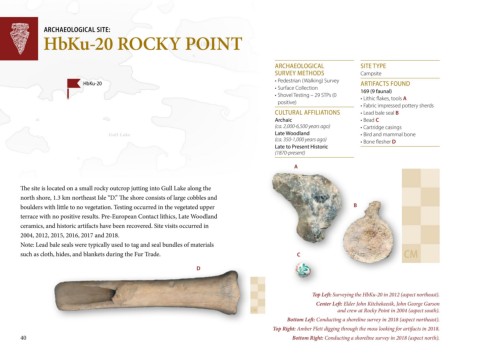
ARCH AEO LO G IC AL SITE:
                HbKu-20 ROCKY POINT
                                                                     Caribou Island


                                                                                                    A R C H A EO LO G IC A L       SITE T YPE
                                                                                                    SU R VEY M E TH O D S          C am p site
                                                                                                    •	Pe d e strian 	(W alkin g )	Su rve y
                               H bKu-20                                                                                            A R TIFAC TS FO U N D
                                                                                                    •	Su rfac e 	C o lle c tio n 	  1 6 9  (9  fa u n a l)
                                                                                                    •	Sh o ve l	Te stin g 	–	29	STPs	(0	  •	Lith ic 	flake s,	to o ls	A
                                                                                                     p o sitive )
                                                                                                                                   •	Fab ric 	im p re sse d 	p o tte ry	sh e rd s
                                                                                                    C U LTU R A L A FFILIATIO N S  •	Le ad 	b ale 	se al	B
                                                                                                    A rc h a ic                    •	Be ad 	C
                                                                                                    (ca . 2,000-6,500 yea rs a g o )   •	C artrid g e 	c asin g s
 Gull Lake                              Gull Lake                                                   L a te  W o o d la n d         •	Bird 	an d 	m am m al	b o n e
                                                                                                    (ca . 350-1,000 yea rs a g o )
 Nelson River                                                                                       L a te  to  P re se n t H isto ric    •	Bo n e 	fle sh e r	D
                                                                                                    (1870-presen t)

 Nelson River                                                                                              A


        The site is located on a small rocky outcrop jutting into Gull Lake along the

        north shore, 1.3 km northeast Isle “D.” The shore consists of large cobbles and
        boulders with little to no vegetation. Testing occurred in the vegetated upper                                          B
        terrace with no positive results. Pre-European Contact lithics, Late Woodland
        ceramics, and historic artifacts have been recovered. Site visits occurred in
        2004, 2012, 2015, 2016, 2017 and 2018.
        Note: Lead bale seals were typically used to tag and seal bundles of materials
        such as cloth, hides, and blankets during the Fur Trade.                                            C                                      C M


                                                                        D


                                                                                                                 Top Left: Surveying the HbKu-20 in 2012 (aspect northeast).
                                                                                                                   Center Left: Elder John Kitchekeesik, John George Garson
                                                                                           C M                             and crew at Rocky Point in 2004 (aspect south).
                                                                                                        Bottom Left: Conducting a shoreline survey in 2018 (aspect northeast).
                                                                                                   Top Right: Amber Flett digging through the moss looking for artifacts in 2018.
        40                                                                                                Bottom Right: Conducting a shoreline survey in 2018 (aspect north).
   43   44   45   46   47   48   49   50   51   52   53